 There’s no doubt that the July heat is in the air, with temperatures on the rise and heat indexes reaching up to 100 degrees.In addition to increased heat, more storms are expected to come through the area, which brings back the threats of flooding.
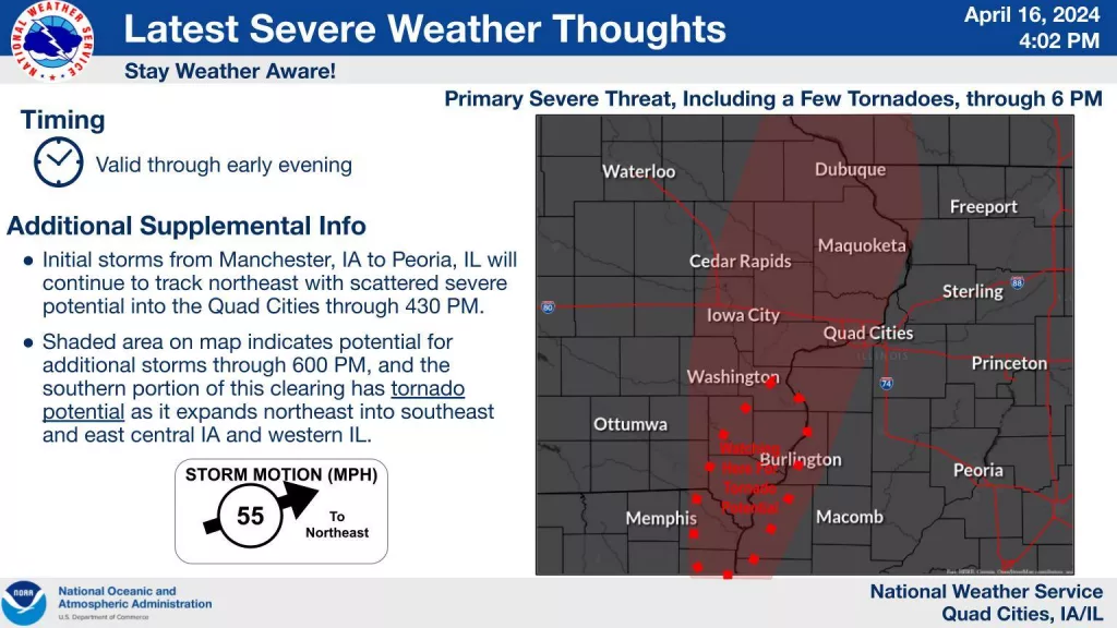
National Weather Service Meteorologist Heather Stanley says the storms should move through the area quickly. The National Weather Service Tornado Scout team is in Galesburg tonight monitoring the storm.
Stanley tells WGIL that temperatures will be warm throughout the week, and heat indexes will be in the 90s.
“Well, it’s going to be warm, definitely we’re expecting temperatures, at least high temperatures are mainly going to be in the 80s,” says Stanley. “There will be some heat indexes into the 90s probably throughout the end of the week.”
Stanley says all the heat in the air causes storms to develop more rapidly. According to a National Weather Service Weather Brief, storms are expected to roll through tonight that could be severe. Winds in excess of 70 miles per hour, hail larger than two inches and possible significant tornadoes EF2 or greater are possible.
Heat Indexes are expected to be in the 105 to 108 degree range. A Heat Advisory was put into effect from noon until 8 p.m. tonight.
River Flooding will continue on the Illinois River for much of the week and portions of the Spoon River over the next couple of days.