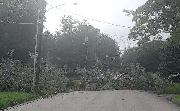

The round of severe weather hitting a large part of the Midwest Monday night including Knox Country was, indeed, a derecho.
The National Weather Service and the Storm Prediction Center made that official Tuesday.
Forecasters define a derecho as a widespread long-lived wind storm associated with a band of rapidly-moving showers and thunderstorms.
And it was that wind that did the most damage here, says Knox County Emergency Management Chief Randy Hovind.
“There were a lot of downed trees, and debris in the road, lots of downed power lines,” said Hovind, who went out surveying damage himself Monday night. “I had come in right about the time the storm hit, and our dispatch center was really, really overwhelmed.”
Hovind tells Galesburg’s Morning News on WGIL it was all hands on deck in the city starting the cleanup of downed trees and limbs, while Ameren did the work of trying to deal with power outages and downed power lines.
As of 1:30pm Tuesday, Knox County had 2,953 customers without power, while Warren County had 456. Henry County has 3,552. Overall, there are currently 37,339 Ameren customers without power in Illinois.
“Crews are working pretty hard to get (debris cleanup and power restoration) accomplished,” said Hovind. “There’s a lot of downed lines. That’s a lot of customers without power. I’m anticipating that the brunt of it will be done (Tuesday). It could take several days.”
At least one tornado is believed to have touched down in Andover in Henry County, while in Kewanee, areas that got damage from storms Sunday night got even more damage Monday night, while Hovind says the Central part of Knox County took the worst of it here.
CLICK HERE for a National Weather Service report of storm damage.